File:British Virgin Islands.jpg

Dimension de sta anteprima: 800 × 533 pixel. Altre risołusion: 320 × 213 pixel | 640 × 427 pixel | 1 024 × 683 pixel | 1 280 × 853 pixel | 2 700 × 1 800 pixel.
File orixenałe (2 700 × 1 800 pixel, dimension del file: 2,89 MB, tipo MIME: image/jpeg)
Somario
| Descrision |
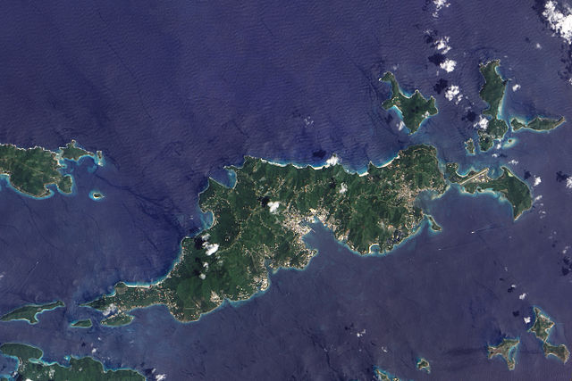
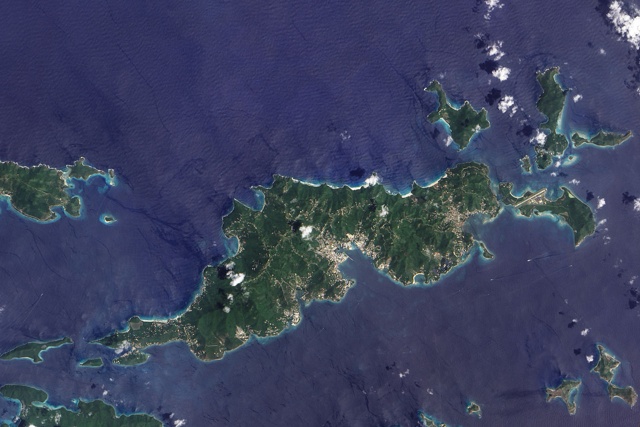
English: This true-colour image of Tortola and its smaller neighbours, Guana Island, Grand Camanoe, and Beef Island. The islands follow a roughly south-west-north-east trajectory. Gray-beige urbanized areas cling to the coast while Tortola’s interior remains mostly green, an arrangement driven by the islands’s topography. The biggest settlement fringes Road Bay. A straight line crossing Beef Island gives away the location of a small airport. Tortola’s carpet of green suggests a lush rainforest, but the island actually supports a patch of drought-resistant forest, in addition to plants accustomed to more water. Tortola’s climate and land surface are well suited to raising livestock, but tourism and financial services are the primary industries. |
| Data | |
| Provenjiensa | NASA Earth Observatory |
| Autore | Jesse Allen |
Image captured by the Advanced Land Imager (ALI) on NASA’s Earth Observing-1 (EO-1) satellite. Image created using EO-1 ALI data provided courtesy of the NASA EO-1 team and the United States Geological Survey. Instrument: EO-1 - ALI.
Licensa de doparasion:
| Sto file multimedial el xe 'ntel publico dominio parché el xe stà creà da la NASA. La polìtega del dirito d'autor de la NASA xe che «el material de la NASA no'l xe proteto dal dirito d'autor via de quando altrimenti spesificà». (Polìtega del dirito d'autor de la NASA e polìtega de l'uso de le imagini del JPL Image Use Policy) | ||
 |
Ocio:
|
| Annotations | This image is annotated: View the annotations at Commons |
Istoria del file
Schicia so on grupo data/or pa vedare el file come che el se presentava in tel momento indegà.
| Data/Ora | Miniadura | Dimension | Utente | Comento | |
|---|---|---|---|---|---|
| In ultima | 14:06, 30 nov 2009 | | 2 700 × 1 800 (2,89 MB) | Originalwana | {{Information |Description={{en|1=This true-colour image of Tortola and its smaller neighbours, Guana Island, Grand Camanoe, and Beef Island. The islands follow a roughly south-west-north-east trajectory. Gray-beige urbanized areas c |
Doparasion del file
Ła pajina che vien ła dopara sto file:
Doparasion globałe del file
St'altre wiki cua le dopara sto file:
- Uxo de af.wikipedia.org inte le pàjine
- Uxo de ar.wikipedia.org inte le pàjine
- Uxo de arz.wikipedia.org inte le pàjine
- Uxo de ast.wikipedia.org inte le pàjine
- Uxo de ca.wikipedia.org inte le pàjine
- Uxo de cy.wikipedia.org inte le pàjine
- Uxo de da.wikipedia.org inte le pàjine
- Uxo de en.wikipedia.org inte le pàjine
- Uxo de eo.wikipedia.org inte le pàjine
- Uxo de fr.wikivoyage.org inte le pàjine
- Uxo de ga.wikipedia.org inte le pàjine
- Uxo de gl.wikipedia.org inte le pàjine
- Uxo de ht.wikipedia.org inte le pàjine
- Uxo de pap.wikipedia.org inte le pàjine
- Uxo de pl.wikipedia.org inte le pàjine
- Uxo de ru.wikinews.org inte le pàjine
- Uxo de tl.wikipedia.org inte le pàjine
- Uxo de tt.wikipedia.org inte le pàjine
- Uxo de uk.wikipedia.org inte le pàjine
- Uxo de www.wikidata.org inte le pàjine