File:West Midlands counties 2009 map.svg

Dimensioni di questa anteprima PNG per questo file SVG: 533 × 600 pixel. Altre risołusion: 213 × 240 pixel | 427 × 480 pixel | 683 × 768 pixel | 910 × 1 024 pixel | 1 821 × 2 048 pixel | 1 161 × 1 306 pixel.
File orixenałe (file en formato SVG, dimension nominałi 1 161 × 1 306 pixel, dimension del file: 1,38 MB)
Somario
| Descrision |
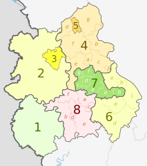
English: Map of the West Midlands region of England, showing its counties and administrative districts. The county colours are the same as those in File:English metropolitan and non-metropolitan counties 2009.svg.
Equirectangular map projection on WGS 84 datum, with N/S stretched 165% Geographic limits:
|
| Data | (UTC) |
| Provenjiensa |
Questo file deriva da: |
| Autore |
|
| Altre version |
 |


| Map | Ceremonial county | Shire county / unitary | Districts |
|---|---|---|---|
 |
1. Herefordshire U.A. | ||
| Shropshire | 2. Shropshire U.A. | ||
| 3. Telford and Wrekin U.A. | |||
| Staffordshire | 4. Staffordshire † | a) Cannock Chase, b) East Staffordshire, c) Lichfield, d) Newcastle-under-Lyme, e) South Staffordshire, f) Stafford, g) Staffordshire Moorlands, h) Tamworth | |
| 5. Stoke-on-Trent U.A. | |||
| 6. Warwickshire † | a) North Warwickshire, b) Nuneaton and Bedworth, c) Rugby, d) Stratford-on-Avon, e) Warwick | ||
| 7. West Midlands * | a) Birmingham, b) Coventry, c) Dudley, d) Sandwell, e) Solihull, f) Walsall, g) Wolverhampton | ||
| 8. Worcestershire † | a) Bromsgrove, b) Malvern Hills, c) Redditch, d) Worcester, e) Wychavon, f) Wyre Forest | ||
Key: †shire county | *metropolitan county
Licensa de doparasion:
Sto file el xe soto ła liçensa Creative Commons Atribusion-Spartisi in te ła stesa manjiera 3.0 Xenèrego.
Atribusion: Dr Greg and Nilfanion. Contains Ordnance Survey data © Crown copyright and database right 2011
- Te si libaro:
- de spartire in jiro – de copiar, distribuir e trasmétar sta opera
- de modifegar – de adatar sta opera
- Soto le seguenti condision:
- atribussion – Te ghe da atribuir ƚa paternità de ƚ'opera ne i modi indicà de l'autor o da chi te gà dà l'opera en lisensa, e en modo tale da no sugerir che lori i sia d'acordo con ti o col modo che te dòpari l'opera.
- spartisi in te ła stesa manjiera – Se te mis-ci, trasformi o dexviłupi sto laoro, te ghè da spartire łe to contribusion segondo ła stesa liçensa o na conpatibiłe a l'orixenałe.
Registro original del caricamento
This image is a derivative work of the following images:
- File:West_Midlands_districts_2011_map.svg licensed with Cc-by-sa-3.0, GFDL
- 2011-05-01T19:06:46Z Nilfanion 1161x1306 (1392730 Bytes) == Summary == {{Information |Description=Map of the [[w:West Midlands|West Midlands]] region showing the administrative districts. Equirectangular map projection on WGS 84 datum, with N/S stretched 165% Geographic limits: *
- File:English_ceremonial_counties_2010.svg licensed with Cc-by-sa-3.0, GFDL
- 2010-11-23T16:39:55Z Nilfanion 1108x1345 (308868 Bytes) thicker lines
- 2010-11-23T16:20:19Z Nilfanion 1108x1345 (301520 Bytes) tweaks
- 2010-10-26T20:34:20Z Nilfanion 817x990 (1391832 Bytes) {{Information |Description=Map showing the [[w:ceremonial counties of England]] including the City of London, in 2010. Equirectangular map projection on WGS 84 datum, with N/S stretched 170% Geographic limits: *West: 6.75W
Uploaded with derivativeFX
Istoria del file
Schicia so on grupo data/or pa vedare el file come che el se presentava in tel momento indegà.
| Data/Ora | Miniadura | Dimension | Utente | Comento | |
|---|---|---|---|---|---|
| In ultima | 22:01, 5 maj 2012 | | 1 161 × 1 306 (1,38 MB) | Dr Greg | lighten black boundary line |
| 23:19, 2 maj 2012 |  | 1 161 × 1 306 (1,38 MB) | Dr Greg | == {{int:filedesc}} == {{Information |Description={{en|Map of the West Midlands region of England, showing its counties and administrative districts. The county colours are the same as those in [[:File:English metropolitan ... |
Doparasion del file
Ła pajina che vien ła dopara sto file:
Doparasion globałe del file
St'altre wiki cua le dopara sto file:
- Uxo de ar.wikipedia.org inte le pàjine
- Uxo de de.wikipedia.org inte le pàjine
- Uxo de en.wikipedia.org inte le pàjine
- Uxo de fa.wikipedia.org inte le pàjine
- Uxo de frr.wikipedia.org inte le pàjine
- Uxo de fr.wikipedia.org inte le pàjine
- Uxo de hr.wikipedia.org inte le pàjine
- Uxo de hu.wikipedia.org inte le pàjine
- Uxo de mr.wikipedia.org inte le pàjine
- Uxo de pl.wikipedia.org inte le pàjine
- Uxo de pnb.wikipedia.org inte le pàjine
- Uxo de pt.wikipedia.org inte le pàjine
- Uxo de th.wikipedia.org inte le pàjine
- Uxo de tr.wikipedia.org inte le pàjine
- Uxo de ur.wikipedia.org inte le pàjine
- Uxo de vi.wikipedia.org inte le pàjine
- Uxo de vls.wikipedia.org inte le pàjine
- Uxo de zh-yue.wikipedia.org inte le pàjine