File:Celts in Europe-fr.svg

Dimensioni di questa anteprima PNG per questo file SVG: 800 × 592 pixel. Altre risołusion: 320 × 237 pixel | 640 × 473 pixel | 1 024 × 757 pixel | 1 280 × 947 pixel | 2 560 × 1 893 pixel | 933 × 690 pixel.
File orixenałe (file en formato SVG, dimension nominałi 933 × 690 pixel, dimension del file: 165 KB)
Somario
| Descrision |
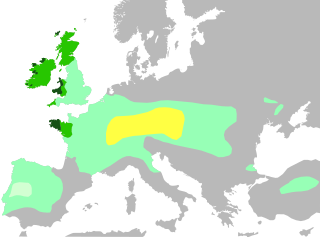
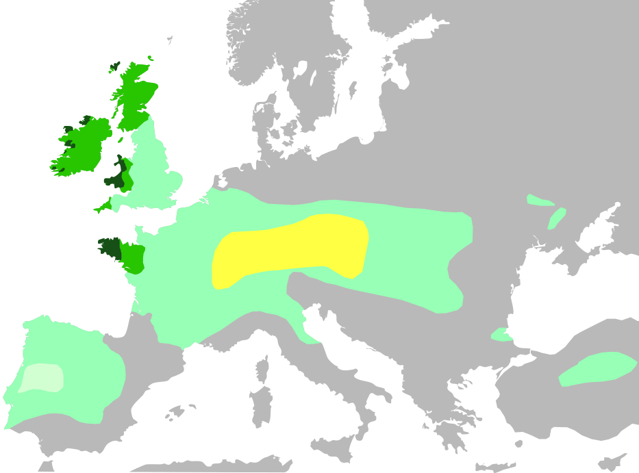
Français : Cette carte montre :
Noyau territorial Hallstatt, au VI siècle avant J.-C.
Expansion celtique maximale, en 275 avant J.-C.
Domaine lusitanien de l'Ibérie où la présence celtique est incertaine
Les six nations celtiques officielles aujourd'hui et qui pratiquaient le langage celtique au Moyen Âge (Bretagne, Pays de Galles, Cornouailles, Ile de Man, Irlande, Ecosse)
Zones où les langues celtiques restent largement parlées aujourd'hui English: Celts in Europe
the core Hallstatt territory, expansion before 500 BCE
maximum Celtic expansion by the 270s BCE
Lusitanian area of Iberia, "Celticity" uncertain
the boundaries of the six commonly-recognized 'Celtic nations', which remained Celtic speaking throughout the Middle Ages (viz. Brittany, Wales, Cornwall, Isle of Man, Ireland, Scotland)
areas that remain Celtic-speaking today Deutsch: Verbreitung keltischer Völker und Sprachen: Gebiet der Hallstatt-Kultur im 6. Jahrhundert v. Chr.
Größte keltische Ausdehnung, um 275 v. Chr.
Lusitania (keltische Besiedlung unsicher)
Die „sechs Keltischen Nationen“ in denen es bis in die Frühe Neuzeit eine signifikante Anzahl Sprecher keltischer Sprachen gab.
Das heutige Verbreitungsgebiet keltischer Sprachen |
| Data | |
| Provenjiensa | |
| Autore | QuartierLatin1968, The Ogre, Dbachmann, Superwikifan; derivative work Augusta 89 |
| Altre version |
|

Licensa de doparasion:
Mi, che detegno el dirito d'autor su sta opera, la pùblico qua soto la seguente licensa:
Sto file el xe soto ła liçensa Creative Commons Atribusion-Spartisi in te ła stesa manjiera 3.0 Xenèrego.
- Te si libaro:
- de spartire in jiro – de copiar, distribuir e trasmétar sta opera
- de modifegar – de adatar sta opera
- Soto le seguenti condision:
- atribussion – Te ghe da atribuir ƚa paternità de ƚ'opera ne i modi indicà de l'autor o da chi te gà dà l'opera en lisensa, e en modo tale da no sugerir che lori i sia d'acordo con ti o col modo che te dòpari l'opera.
- spartisi in te ła stesa manjiera – Se te mis-ci, trasformi o dexviłupi sto laoro, te ghè da spartire łe to contribusion segondo ła stesa liçensa o na conpatibiłe a l'orixenałe.
Istoria del file
Schicia so on grupo data/or pa vedare el file come che el se presentava in tel momento indegà.
| Data/Ora | Miniadura | Dimension | Utente | Comento | |
|---|---|---|---|---|---|
| In ultima | 20:35, 4 nov 2016 | | 933 × 690 (165 KB) | Rob984 | Adjusted colour of sea and land to conform to widely used grey-white style, which I think looks better. Adds focus on the colour part of the map. |
| 18:04, 3 luj 2014 |  | 933 × 695 (274 KB) | Kopiersperre | same colours like in File:Celts in Europe.png | |
| 14:04, 14 xug 2014 |  | 933 × 695 (274 KB) | Augusta 89 | User created page with UploadWizard |
Doparasion del file
Ła pajina che vien ła dopara sto file:
Doparasion globałe del file
St'altre wiki cua le dopara sto file:
- Uxo de arz.wikipedia.org inte le pàjine
- Uxo de ast.wikipedia.org inte le pàjine
- Uxo de ca.wikipedia.org inte le pàjine
- Uxo de de.wikipedia.org inte le pàjine
- Uxo de de.wikivoyage.org inte le pàjine
- Uxo de en.wikipedia.org inte le pàjine
- Uxo de es.wikipedia.org inte le pàjine
- Uxo de eu.wikipedia.org inte le pàjine
- Uxo de fr.wikipedia.org inte le pàjine
- Uxo de fr.wikibooks.org inte le pàjine
- Uxo de ga.wikipedia.org inte le pàjine
- Uxo de gl.wikipedia.org inte le pàjine
- Uxo de hu.wikipedia.org inte le pàjine
- Uxo de lv.wikipedia.org inte le pàjine
- Uxo de pcd.wikipedia.org inte le pàjine
- Uxo de pt.wikipedia.org inte le pàjine
- Uxo de rm.wikipedia.org inte le pàjine
- Uxo de www.wikidata.org inte le pàjine
- Uxo de zh.wikipedia.org inte le pàjine