File:Lombardy.satellite.jpg

Dimension de sta anteprima: 600 × 600 pixel. Altre risołusion: 240 × 240 pixel | 480 × 480 pixel | 768 × 768 pixel | 1 024 × 1 024 pixel | 2 048 × 2 048 pixel | 4 055 × 4 055 pixel.
File orixenałe (4 055 × 4 055 pixel, dimension del file: 15,2 MB, tipo MIME: image/jpeg)
Somario
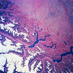
| Descrision | Several elongated lakes (dark features) are identifiable in this southerly view of the Italian-Swiss border. The elongated lakes are the creation of alpine (or valley) glaciers that moved generally southward through this section of the Italian Alps over 12000 years ago. From west to east the four larger lakes are Maggiore (lower right corner), Lugana, Como, and d'Iseo (upper left corner). Smaller lakes (also dark features) are visible at the southern end of Lake Como (center of image) and Lake Maggiore. Subtle faults that are perpendicular to the southern end of the lakes can be traced east to west across the landscape at the base of the Italian Alps. Glaciated, U-shaped valleys are discernible north and northeast of the lakes. The color infrared helps to identify the densely vegetated mountain slopes where the forested land (green vegetation) is shown as concentrations of reddish patterns. The relatively flat plains of the highly industrialized and agriculturally productive Po River Valley (upper third of image) presents a dramatically different looking terrain than the snow covered mountainous region of northern Italy. |
| Data | Winter/Spring 1997 |
| Provenjiensa | Here |
| Autore | Image Science and Analysis Laboratory, NASA-Johnson Space Center. 18 Mar. 2005. "Earth from Space - Image Information." |
Questa immagine o filmato è stato catalogato da uno dei centri della National Aeronautics and Space Administration (NASA) degli Stati Uniti d'Americacon il Photo ID: NM23-776-834.Questo tag non indica lo status del copyright dell'opera ad esso associato. È quindi richiesto un normale tag di copyright. Vedi Commons:Licenze per maggiori informazioni. Altre lingue:
|
Licensa de doparasion:
| Sto file multimedial el xe 'ntel publico dominio parché el xe stà creà da la NASA. La polìtega del dirito d'autor de la NASA xe che «el material de la NASA no'l xe proteto dal dirito d'autor via de quando altrimenti spesificà». (Polìtega del dirito d'autor de la NASA e polìtega de l'uso de le imagini del JPL Image Use Policy) | ||
 |
Ocio:
|
Istoria del file
Schicia so on grupo data/or pa vedare el file come che el se presentava in tel momento indegà.
| Data/Ora | Miniadura | Dimension | Utente | Comento | |
|---|---|---|---|---|---|
| In ultima | 23:18, 24 luj 2023 | | 4 055 × 4 055 (15,2 MB) | Don-vip | |
| 21:05, 5 ago 2006 |  | 639 × 639 (391 KB) | Lange~commonswiki | {{Information |Description= Several elongated lakes (dark features) are identifiable in this southerly view of the Italian-Swiss border. The elongated lakes are the creation of alpine (or valley) glaciers that moved generally southward through this sectio |
Doparasion del file
Ła pajina che vien ła dopara sto file:
Doparasion globałe del file
St'altre wiki cua le dopara sto file:
- Uxo de arz.wikipedia.org inte le pàjine
- Uxo de ast.wikipedia.org inte le pàjine
- Uxo de az.wikipedia.org inte le pàjine
- Uxo de bg.wikipedia.org inte le pàjine
- Uxo de ca.wikipedia.org inte le pàjine
- Uxo de cy.wikipedia.org inte le pàjine
- Uxo de de.wikivoyage.org inte le pàjine
- Uxo de diq.wikipedia.org inte le pàjine
- Uxo de fi.wikipedia.org inte le pàjine
- Uxo de fr.wikipedia.org inte le pàjine
- Uxo de fr.wikivoyage.org inte le pàjine
- Uxo de ga.wikipedia.org inte le pàjine
- Uxo de gd.wikipedia.org inte le pàjine
- Uxo de gl.wikipedia.org inte le pàjine
- Uxo de he.wikipedia.org inte le pàjine
- Uxo de hy.wikipedia.org inte le pàjine
- Uxo de ia.wikipedia.org inte le pàjine
- Uxo de id.wikipedia.org inte le pàjine
- Uxo de ilo.wikipedia.org inte le pàjine
- Uxo de it.wikipedia.org inte le pàjine
- Uxo de ka.wikipedia.org inte le pàjine
- Uxo de ku.wikipedia.org inte le pàjine
- Uxo de la.wikipedia.org inte le pàjine
- Uxo de mzn.wikipedia.org inte le pàjine
- Uxo de nn.wikipedia.org inte le pàjine
- Uxo de no.wikipedia.org inte le pàjine
- Uxo de oc.wikipedia.org inte le pàjine
- Uxo de pl.wikipedia.org inte le pàjine
- Uxo de ro.wikipedia.org inte le pàjine
- Uxo de ru.wikipedia.org inte le pàjine
- Uxo de ru.wikinews.org inte le pàjine
- Uxo de sl.wikipedia.org inte le pàjine
- Uxo de sr.wikipedia.org inte le pàjine
- Uxo de tt.wikipedia.org inte le pàjine
- Uxo de uk.wikipedia.org inte le pàjine
- Uxo de vi.wikipedia.org inte le pàjine
- Uxo de www.wikidata.org inte le pàjine