File:Spring in the Canadian Arctic.jpg

File orixenałe (3 800 × 4 600 pixel, dimension del file: 3,33 MB, tipo MIME: image/jpeg)
Somario
| Descrision |
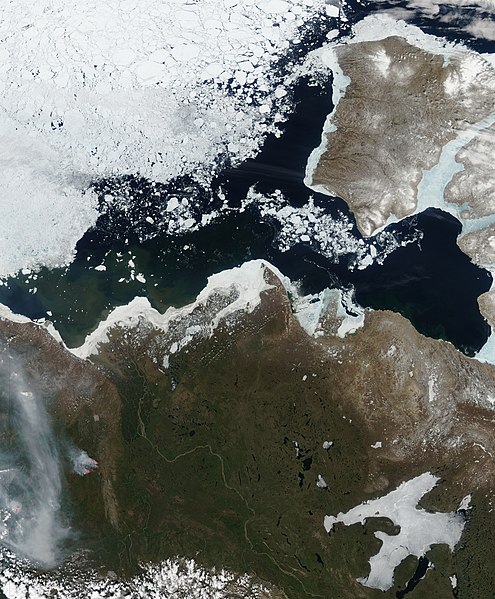
English: This image shows the western Canadian Arctic a few days after perpetual sunlight commenced for the entire region. The image captures the Arctic in a moment of transformation. Signs of winter are still present, but summer is clearly on the horizon. Sea ice in the Beaufort Sea has started to break up. A swath of open water, black in this image, separates the land from the dense pack of sea ice. Ice still fringes much of the land, but it is thinning. In many places, particularly around Banks Island, the land-bound sea ice is blue, pointing to thin ice or the presence of water on the ice.
Spring is beginning to touch land as well. While frozen lakes punctuate the landscape with white, many lakes are clear. The Mackenzie River flows ice-free to a broad partially frozen delta. Trapped behind a dam of ice, the muddy brown waters blur across the triangular delta. The water that is getting through the ice carries sediment into the Beaufort Sea, colouring the waters near the shore brown and green. With access to constant light, flowing water, and warmer temperatures, plants are beginning to grow. The land around the Mackenzie River has a deep green hue. The line between tundra and forest runs through this image. The forest is dark green, while the tundra is still brown. The land also shows the first sign of summer: large forest fires. One large forest fire is outlined in red. Smoke from nearby fires flows across the lower left corner of the image. The boreal forest needs fire to maintain the ecosystem, and large fires happen regularly in the summer. In the remote region shown here, lightning ignites most forest fires. |
| Data | |
| Provenjiensa | NASA Earth Observatory |
| Autore | Jeff Schmaltz |
Image captured by the Moderate Resolution Imaging Spectroradiometer (MODIS) on NASA’s Aqua satellite. Image courtesy of the MODIS Rapid Response Team at NASA GSFC.
Licensa de doparasion:
| Sto file multimedial el xe 'ntel publico dominio parché el xe stà creà da la NASA. La polìtega del dirito d'autor de la NASA xe che «el material de la NASA no'l xe proteto dal dirito d'autor via de quando altrimenti spesificà». (Polìtega del dirito d'autor de la NASA e polìtega de l'uso de le imagini del JPL Image Use Policy) | ||
 |
Ocio:
|
| Annotations | This image is annotated: View the annotations at Commons |
Istoria del file
Schicia so on grupo data/or pa vedare el file come che el se presentava in tel momento indegà.
| Data/Ora | Miniadura | Dimension | Utente | Comento | |
|---|---|---|---|---|---|
| In ultima | 12:40, 16 xug 2010 | | 3 800 × 4 600 (3,33 MB) | Originalwana | {{Information |Description={{en|1=This image shows the western Canadian Arctic a few days after perpetual sunlight commenced for the entire region. The image captures the Arctic in a moment of transformation. Signs of winter |
Doparasion del file
Nisuna pajina ła dopara sto file
Doparasion globałe del file
St'altre wiki cua le dopara sto file:
- Uxo de af.wikipedia.org inte le pàjine
- Uxo de ckb.wikipedia.org inte le pàjine
- Uxo de en.wikipedia.org inte le pàjine
- Uxo de ms.wikipedia.org inte le pàjine
- Uxo de sl.wikipedia.org inte le pàjine
- Uxo de zh.wikibooks.org inte le pàjine