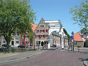
Hoorn
Hoorn el xe on comun dei Paexi Basi, situà inte ła provinsa de l'Ołanda Setentrionałe.
| Hoorn (nl) | |||||
|---|---|---|---|---|---|
|
|||||
 | |||||
| Pozision | |||||
| Stato | Regno dei Paezi Basi | ||||
| Stato del Regno dei Paesi Bassi (it) | Paezi Basi | ||||
| Provinse dei Paexi Basi | Ołanda Setentrionałe | ||||
| Capitałe | Hoorn (en) | ||||
| Popołasion | |||||
| Totałe | 73 619 (2021) | ||||
| Densità | 1 411,14 hab./km² | ||||
| Caze abitae | 32 192 (2015) | ||||
| Zeografia | |||||
| Àrea | 52,17 km²[2] | ||||
| Àcua | 61,88 % | ||||
| Bagnà da | Markermeer | ||||
| Altitùdene | −1 m | ||||
| Rente a | |||||
| Organizasion pułìtega | |||||
| Borgomastro de Hoorn | Jan Nieuwenburg (it) | ||||
| Còdazi de identifegasion | |||||
| Còdaze postałe | 1620–1628, 1689 e 1695 | ||||
| Fuzo oràrio | |||||
| Sito web | hoorn.nl | ||||
|
| |||||
Evołusion demogràfega
canbiaAltri projeti
canbia- Wikimedia Commons el detien imàjini o altri file so Hoorn
- el detien schemi gràfeghi so
Linganbi foresti
canbia- (nederlandezo) Sito ufisałehoorn.nl. Sconosesta: nederlandezo (juto)
- Gemeente Hoorn (canale ufisałe)YouTube.
- (EN) HoornEnçiclopedia Britannica, Encyclopædia Britannica, Inc.
- ↑ Declarà da: waar staat je gemeente.nl.
- ↑ Declarà da: register of public bodies. Data de consultasion: 21 de zenaro del 2023.
- ↑ URL de refarensa: https://dans.knaw.nl/nl/over/organisatie-beleid/publicaties/DANSrepertoriumnederlandsegemeenten2011.pdf.


