File:Lake Tiberias (Sea of Galilee), Northern Israel.jpg
Dimension de sta anteprima: 398 × 599 pixel. Altre risołusion: 159 × 240 pixel | 319 × 480 pixel | 510 × 768 pixel | 680 × 1 024 pixel | 1 440 × 2 168 pixel.
File orixenałe (1 440 × 2 168 pixel, dimension del file: 1,15 MB, tipo MIME: image/jpeg)
,_Northern_Israel.jpg)
Somario
| Descrision |
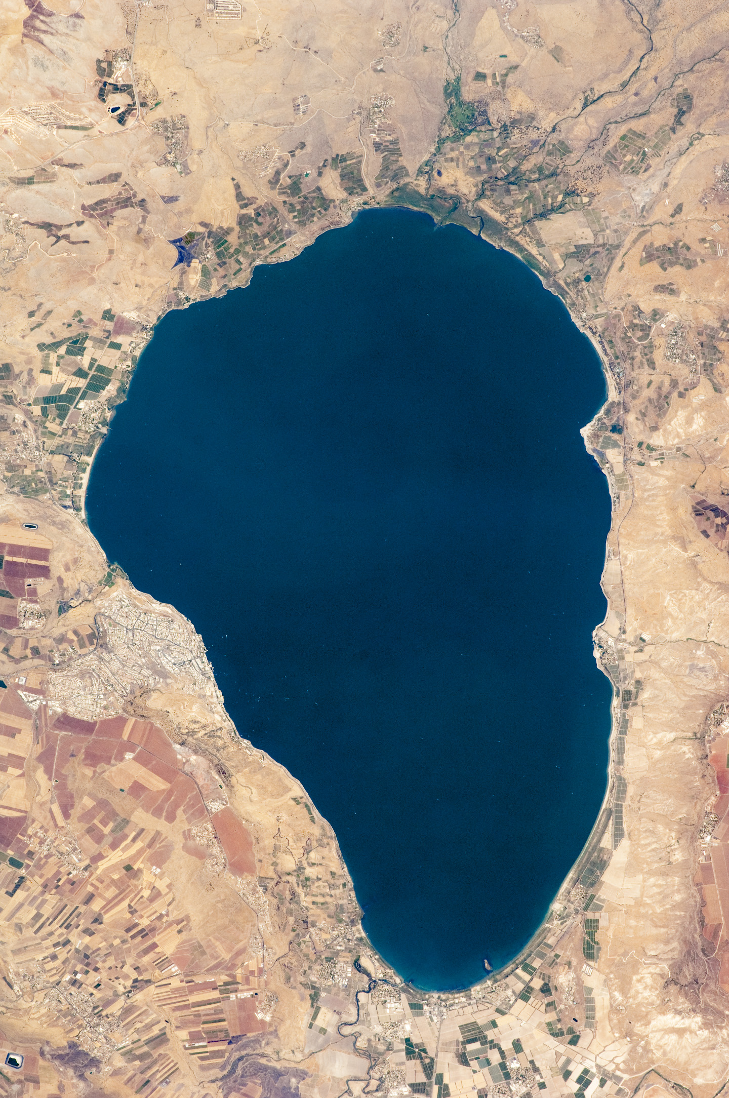
English: Israel’s largest freshwater lake, Lake Tiberias, is also known as the Sea of Tiberias, Lake of Gennesaret, Lake Kinneret, and the Sea of Galilee. The lake measures just more than 21 kilometres north-south, and it is only 43 meters deep. The lake is fed partly by underground springs related to the Jordan sector of the Great Rift Valley, but most of its water comes from the Jordan River, which enters from the north. The river’s winding course can be seen draining the south end of the lake at image bottom. Angular green and brown field patterns clothe most hillsides in this arid landscape. Bright roof tops are the hallmark of several villages in the area. The largest grouping of bright roofs and city blocks indicates the location of Tiberias (named for the Roman Emperor Tiberius), visible at image left on the south-western shore of the lake.
|
||||||||||||||||||||||||||||||||||||||||||||||||||
| Data | |||||||||||||||||||||||||||||||||||||||||||||||||||
| Provenjiensa | NASA Earth Observatory | ||||||||||||||||||||||||||||||||||||||||||||||||||
| Autore | This image was taken by the NASA Expedition 20 crew. | ||||||||||||||||||||||||||||||||||||||||||||||||||
| Altre version | Opere derivate da questo file: (Sea of Galilee Northern Israel-2.jpg | ||||||||||||||||||||||||||||||||||||||||||||||||||
Image acquired with a Nikon D2Xs digital camera fitted with an 400 mm lens, and is provided by the ISS Crew Earth Observations experiment and Image Science & Analysis Laboratory, Johnson Space Centre.
Licensa de doparasion:
| Sto file multimedial el xe 'ntel publico dominio parché el xe stà creà da la NASA. La polìtega del dirito d'autor de la NASA xe che «el material de la NASA no'l xe proteto dal dirito d'autor via de quando altrimenti spesificà». (Polìtega del dirito d'autor de la NASA e polìtega de l'uso de le imagini del JPL Image Use Policy) | ||
 |
Ocio:
|
Istoria del file
Schicia so on grupo data/or pa vedare el file come che el se presentava in tel momento indegà.
| Data/Ora | Miniadura | Dimension | Utente | Comento | |
|---|---|---|---|---|---|
| In ultima | 13:32, 14 set 2009 | | 1 440 × 2 168 (1,15 MB) | Originalwana | {{Information |Description={{en|1=Israel’s largest freshwater lake, Lake Tiberias, is also known as the Sea of Tiberias, Lake of Gennesaret, Lake Kinneret, and the Sea of Galilee. The lake measures just more than 21 kilometres north-south, and it is |
Doparasion del file
Ła pajina che vien ła dopara sto file:
Doparasion globałe del file
St'altre wiki cua le dopara sto file:
- Uxo de af.wikipedia.org inte le pàjine
- Uxo de ar.wikipedia.org inte le pàjine
- Uxo de bn.wikipedia.org inte le pàjine
- Uxo de br.wikipedia.org inte le pàjine
- Uxo de ceb.wikipedia.org inte le pàjine
- Uxo de cy.wikipedia.org inte le pàjine
- Uxo de de.wikipedia.org inte le pàjine
- Uxo de el.wikipedia.org inte le pàjine
- Uxo de en.wikipedia.org inte le pàjine
- Uxo de en.wikivoyage.org inte le pàjine
- Uxo de eo.wikipedia.org inte le pàjine
- Uxo de es.wikipedia.org inte le pàjine
- Uxo de eu.wikipedia.org inte le pàjine
- Uxo de fy.wikipedia.org inte le pàjine
- Uxo de ga.wikipedia.org inte le pàjine
- Uxo de he.wikipedia.org inte le pàjine
- ויקיפדיה:תמונה מומלצת/המלצות קודמות/יולי 2012
- ויקיפדיה:תמונה מומלצת/הוספה למומלצים/ארכיון 40
- תבנית:תמונה מומלצת 23 ביולי 2012
- ויקיפדיה:ערכים מומלצים/המלצות קודמות/יולי 2013
- פורטל:ערכים מומלצים/ערכים/הכנרת
- תבנית:ערך מומלץ 1 ביולי 2013
- תבנית:ערך מומלץ 2 ביולי 2013
- ויקיפדיה:ערכים מומלצים/המלצות קודמות/פברואר 2018
- תבנית:ערך מומלץ 11 בפברואר 2018
- תבנית:ערך מומלץ 12 בפברואר 2018
- Uxo de he.wikivoyage.org inte le pàjine
- Uxo de hy.wikipedia.org inte le pàjine
- Uxo de ia.wikipedia.org inte le pàjine
- Uxo de id.wikipedia.org inte le pàjine
Varda ła doparasion globałe de sto file.
,_Northern_Israel.jpg)
,_Northern_Israel.jpg)