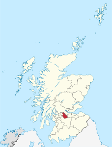
Lanarkshire de Sora
El Lanarkshire de Sora (gaelico scoseze Siorrachd Lannraig a Tuath) el xe on'area aministrativa de ła Scozia.
 | |
| Pozision | |
|---|---|
| Stato | Regno Unio |
| Nasion costitutiva | Scòsia |
| Capitałe | Motherwell (it) |
| Popołasion | |
| Totałe | 340 180 (2018) |
| Densità | 723,93 hab./km² |
| Zeografia | |
| Parte de | Glasgow and Clyde Valley City Region (en) |
| Àrea | 469,9094 km²[1] |
| Rente a | |
| Còdazi de identifegasion | |
| ISO 3166-2 | GB-NLK[2] |
| Catàłogo | NRS list of Scottish council areas (en) |
| Còdaze NUTS | UKM36 |
| Sito web | northlan.gov.uk |
|
| |
Località
canbia- Airdrie
- Allanton
- Auchinloch
- Annathill
- Banton
- Bargeddie
- Bellshill
- Calderbank
- Caldercruix
- Carfin
- Chapelhall
- Chryston
- Cleland
- Coatbridge
- Croy
- Cumbernauld
- Dullatur
- Forrestfield
- Gartcosh
- Glenboig
- Glenmavis
- Greengairs & Wattson
- Harthill
- Holytown
- Kilsyth
- Longriggend
- Mollinsburn
- Moodiesburn
- Motherwell
- Newmains
- Newarthill
- New Stevenston
- Overtown
- Plains
- Queenzieburn
- Riggend
- Salsburgh
- Shotts
- Stand
- Stepps
- Tannochside
- Viewpark
- Wishaw
Altri projeti
canbia- Wikimedia Commons el detien imàjini o altri file so Lanarkshire de Sora
- el detien schemi gràfeghi so
- Wikimedia Commons el detien imàjini o altri file so Lanarkshire de Sora
- el detien schemi gràfeghi so
- ↑ URL de refarensa: https://ons.maps.arcgis.com/home/item.html?id=a79de233ad254a6d9f76298e666abb2b.
- ↑ Declarà da: MusicBrainz. Łéngua de l'òpara: inglezo. Editor: MetaBrainz Foundation.
