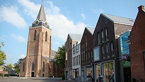
Woerden
Woerden el xe un comun dei Paexi Basi, situà inte ła provinsa de Utrecht.
| Woerden (nl) | |||||
|---|---|---|---|---|---|
|
|||||
 | |||||
| Pozision | |||||
| Continente | Eoropa | ||||
| Stato | Regno dei Paezi Basi | ||||
| Stato del Regno dei Paesi Bassi (it) | Paezi Basi | ||||
| Provinse dei Paexi Basi | Utrecht (provinsa) | ||||
| Capitałe | Woerden (en) | ||||
| Popołasion | |||||
| Totałe | 52 694 (2021) | ||||
| Densità | 567,09 hab./km² | ||||
| Caze abitae | 20 903 (2015) | ||||
| Zeografia | |||||
| Àrea | 92,92 km² | ||||
| Bagnà da | Oude Rijn (it) | ||||
| Altitùdene | 0 m | ||||
| Rente a | |||||
| Prima mesion documentada | Kamerik (en) | ||||
| Organizasion pułìtega | |||||
| Òrgano ezecutivo | college van burgemeester en wethouders de Woerden (en) | ||||
| Borgomastro de Woerden | Jan J. Bos (it) | ||||
| Còdazi de identifegasion | |||||
| Còdaze postałe | 3440–3449 | ||||
| Fuzo oràrio | |||||
| Prefiso tełefònego | 0348 | ||||
| Istòrego | |||||
| Sito web | woerden.nl | ||||
|
| |||||
Evołusion demogràfega
canbiaAltri projeti
canbia- Wikimedia Commons el detien imàjini o altri file so Woerden
- el detien schemi gràfeghi so
Linganbi foresti
canbia- Sito ufisałewoerden.nl.
- Sito ufisałewoerden.nl.
| Controło de autorità | VIAF (EN) 145479235 · LCCN (EN) n85083715 · GND (DE) 4497881-9 · BNF (FR) cb13329222j (data) · WorldCat Identities (EN) n85-083715 |
|---|
- ↑ Declarà da: waar staat je gemeente.nl.
- ↑ URL de refarensa: https://dans.knaw.nl/nl/over/organisatie-beleid/publicaties/DANSrepertoriumnederlandsegemeenten2011.pdf.


